|
|
|
Week of May 30, 2011 |
| Hunting & Shooting Products/Issues |
| National |
| Regional |
| Illinois |
| Indiana |
| Michigan |
| New York |
| Wisconsin |
| Other Breaking News Items |
|
or |
![]()
Hunting & Shooting Products/Issues
|
Bushnell Field Scan Time Lapse Software Improves the most reliable trail camera in the woods Bushnell has partnered with "Scouting Assistant" to introduce a new software application for Trophy Cam users. Field Scan Time Lapse software allows users to review days of time-lapse images in minutes thanks to sophisticated motion search technology.
Bushnell introduced Field Scan
technology with the 2011
Field Scan Time Lapse software allows users to import time lapse image collections from an SD card to the computer, and quickly review the frames with variable speed playback. With the software's motion search technology, users can create custom searches and efficiently scan captured images for key frames. Photo sets can ultimately be converted to high speed motion video that can be easily viewed or shared. |
Each 2011 Bushnell Trophy Cam includes one free license for the Field Scan Time Lapse software. Software download and registration instructions are available with product literature or can be accessed online. For more info about the complete line of Bushnell Trophy Cam trail cameras, visit the product section online.
Features Include: 8 MP high-quality full color resolution Day/night autosensor External power compatible Adjustable PIR (Lo/Med/High) 1-second trigger speed Programmable trigger interval: 1 sec. to 60 min. Multi-image mode: 1-3 images per trigger Video length: 1 second to 60 seconds, programmable Field Scan time-lapse mode takes images at pre-set intervals: 1 minute to 60 minutes Temperature range -5� F to 140� F PIR sensor is motion activated out to 45 ft. Runs up to one year on one set of batteries Adjustable web belt and 1/4-20 socket SD card slot
About $ 295.00 - 445.00 (includes software)
800-423-3537
|
![]()
![]()
National
|
National Ocean
Council Regional Listening Sessions
|
Session topics include:
|
|
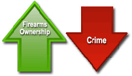
Violent Crime drops as Firearms ownership Rises FBI releases preliminary figures for 2010 FBI Data Proves Anti-Gunners Wrong on Crime
Preliminary
crime data from the FBI for 2010 adds more evidence that gun prohibitionists
have been consistently wrong, and that more guns do not equal more crime,
the Citizens Committee for the Right to Keep and Bear Arms said.
Final figures for 2009 showed violent crime at its lowest level since 1984. At the same time, firearms ownership and use has been increasing, putting the lie to anti-gun organizations' claims that more guns lead to more crime. The largest surge in firearms sales occurred from late 2008 into 2010, and, according to an NSSF report, an estimated 34.4 million people went target shooting in 2009, the largest number ever.
According to the FBI, the nation also experienced a 2.8 % decline in the number of property crimes in 2010 when compared with data from 2009. The report is based on information the FBI gathered from 13,007 law enforcement agencies that submitted six to 12 comparable months of data for both 2009 and 2010.
■Violent crime declined in all city groups. Cities with populations of 250,000 to 499,999 saw the greatest decline in violent crime (6.9 %). Violent crime in non-metropolitan counties decreased 6.4 %, and in metropolitan counties, it declined 6.0 %.
|
■Murder and non-negligent manslaughter offenses dropped 25.2 % in the nation�s smallest cities (under 10,000 in population). However, in cities with populations of 250,000 to 499,999, murder and non-negligent manslaughter offenses increased 3.0 %. ■All city and county groupings experienced a decline in forcible rapes except in cities with 500,000 to 999,999 inhabitants, which showed the only rise in forcible rapes (1.9 %). ■Robbery offenses decreased in all city/county groups, with the largest decrease (10.9 %) in cities with 500,000 to 999,999 inhabitants. ■Aggravated assaults decreased in all city groups. Cities with 250,000 to 499,999 inhabitants experienced the greatest decrease (5.5 percent). Aggravated assaults declined in both county groups, with the largest decrease (5.8 percent) reported in non-metropolitan counties. ■Violent crime decreased in all four regions of the country in 2010. There was a 7.5 percent decrease in violent crime in the South, a 5.9 decline in the Midwest, a 5.8 percent decrease in the West, and a 0.4 percent decline in the Northeast.
Property Crime ■All property crime offense categories�burglary, larceny-theft, and motor vehicle theft�decreased in 2010 when compared with 2009 data. Motor vehicle theft showed the largest drop (7.2 percent), followed by larceny-theft, which decreased 2.8 percent, and burglary, which declined 1.1 percent. ■Property crime decreased in all city groupings. Cities with 500,000 to 999,999 inhabitants had the greatest decrease in property crime (4.0 percent). Property crime decreased 1.9 percent in metropolitan counties but increased 2.0 percent in non-metropolitan counties. ■Burglary offenses increased 1.3 percent in cities with 25,000 to 49,999 persons. Burglaries also increased in nonmetropolitan counties by 1.2 percent. ■Larceny-theft offenses decreased in all city groupings. However, in non-metropolitan counties, larceny-thefts rose 3.2 percent. ■Motor vehicle thefts declined in all population groupings. Cities with less than 10,000 inhabitants experienced the greatest decline (10.8 percent). Metropolitan counties reported a 6.9 percent decrease in motor vehicle thefts. ■All four of the nation�s regions had decreases in property crime in 2010 when compared with data from 2009. The greatest decrease in 2010 was in the South, where property crime was down 3.8 percent, followed by a 2.7 percent decline in the Midwest, a 2.5 percent decrease in the West, and a 0.5 percent decrease in the Northeast.
|
![]()
![]()
Regional
|
Utilities companies join forces to battle Sea Lamprey Altered water flow to improve trapping and remove lampreys from Lakes ANN ARBOR, MI�The Great Lakes Fishery Commission launched a major initiative last week to significantly enhance sea lamprey trapping on the St. Marys River. The effort, conceived collaboratively by the Great Lakes Fishery Commission and the International Joint Commission�s International Upper Great Lakes Study, is designed to remove large numbers of the noxious, invasive pest before they have a chance to spawn and contribute to the next generation. The enhanced trapping�conducted in partnership with Brookfield Renewable Power in Sault Ste. Marie, Ontario and Cloverland Electric Cooperative in Sault Ste. Marie, Michigan�will involve a change in the timing and volume of water provided to the two companies for their electricity generation.
Anglers and other users may notice different-than-usual conditions in the St. Marys River rapids due to re-distribution of water through the compensating gates. The International Joint Commission and its Lake Superior Board of Control, which has authority over water flow levels, facilitated the conditions for this initiative. This work is funded in part through the Great Lakes Restoration Initiative.
The St. Marys River is a significant source of sea lampreys and can produce more sea lampreys than all other Great Lakes tributaries combined. In addition to spot treatments with lampricides and the release of sterilized male sea lampreys, trapping of spawning sea lampreys is a major component of the control program on the St. Marys River. |
The commission has been working with Brookfield Renewable Power and Cloverland Electric Cooperative for many years to seek ways to improve trapping�some of the most effective trapping sites are located at power facilities, as the higher flows produced at the power facilities are more attractive to sea lampreys.
Evidence shows that trapping can likely be enhanced with increased water flows at night, when sea lampreys are most active and trapping most successful. Power companies, however, normally decrease flows during the night (off-peak hours) to curtail power generation during times of reduced power demands. To help in the sea lamprey control effort, Brookfield Renewable Power and Cloverland Electric Cooperative have agreed to increase flows during off-peak hours on alternate nights so the commission can determine the effect of increased flows on the efficiency of sea lamprey traps placed at the power facilities.
The International Joint Commission, through its Lake Superior Board of Control, approved the increased water allocation in support of the sea lamprey control program. The water flow�over the course of this operation�cannot exceed a total water limit, known as �Criterion C in Plan 1977A,� the regulations governing the outflow of Lake Superior. In the unlikely event that the �Criterion C� level is reached, this sea lamprey control operation will end and the power companies will forego additional power generation.
The Great Lakes Fishery Commission is conducting this work in careful coordination with the U.S. Army Corps of Engineers, the Ontario Ministry of Natural Resources, the Michigan Department of Natural Resources, Parks Canada, the Batchewana First Nations, and other key stakeholders. |
||||||||||||||||||||||||||||||||||||
|
Weekly Great Lakes Water Levels for WEATHER CONDITIONS Temperatures in the Great Lakes basin were above average last weekend. Most areas of the basin experienced temperatures that were at least 10 degrees above average, and these temperatures persisted in the eastern and southern portions of the basin through Monday. Temperatures fell on Tuesday and remained below average on Wednesday, when a severe thunderstorm system dropped significant rain on large swaths of the Great Lakes basin. Cities like Toledo, OH and Chicago, IL received around 2 inches of rainfall on Wednesday, while Fort Wayne, IN experienced a deluge of nearly 3.5 inches. Temperatures will remain below average into Friday, with many areas seeing temperatures that are more than 10 degrees below average. Temperatures are expected to rise on Sunday and Memorial Day, and showers are predicted during the weekend. LAKE LEVEL CONDITIONS Lakes Superior and Michigan-Huron have reached their levels of a year ago. Lakes St. Clair, Erie, and Ontario are 9, 12, and 23 inches, respectively, higher than they were at this time last year. Over the thirty days, Lakes Superior and Michigan-Huron are projected to climb 4 and 3 inches, respectively. The water levels of Lakes St. Clair, Erie, and Ontario are all expected to remain steady over the next month. FORECASTED MONTHLY OUTFLOWS/CHANNEL CONDITIONS Lake Superior's outflow through the St. Mary's River is projected to be below average for the month of May. The |
outflows from Lake Huron into the St. Clair River, and from Lake St. Clair into the Detroit River, are expected to be below average throughout the month of May. Lake Erie's outflow through the Niagara River is predicted to be above average and the outflow of Lake Ontario into the St. Lawrence River is predicted to be near average. ALERTS The water level of Lake Superior is below chart datum. Lake Superior is forecasted to remain below chart datum until July. Users of the Great Lakes, connecting channels and St. Lawrence River should keep informed of current conditions before undertaking any activities that could be affected by changing water levels. Mariners should utilize navigation charts and refer to current water level readings.
|
![]()
![]()
Illinois
|
IDNR to host Open Houses on Waterfowl Seasons Seek public input on upcoming seasons SPRINGFIELD, IL � Waterfowl hunters interested in learning more about plans for duck and goose seasons in Illinois are invited to attend one of the five public open house meetings the Illinois Department of Natural Resources (IDNR) will host in June.
At each public open house, IDNR staff will provide information on proposed duck zones and season date options for the next five-year period, as well as aerial waterfowl surveys, weather and freeze-up data, and hunter survey data.
Those attending the open houses will have the opportunity to comment on their preferences for the upcoming waterfowl seasons. That input will help IDNR staff develop recommendations for waterfowl zone boundary changes, duck season dates and season dates for Canada goose hunting.
IDNR hopes to set duck zone lines, duck season dates and Canada goose season dates for the next five years, subject to approval by the U.S. Fish and Wildlife Service |
(USFWS). The USFWS is considering a proposal from Illinois and other states that would allow states two additional options in establishing duck zones: four zones, or three zones with a split into two season segments in each zone. The additional duck zone options could be implemented for the 2011-2015 seasons. IDNR believes the best option for Illinois would be to use four zones without the option to split the season because of the vast differences in the timing of duck migration from north to south in this state (more than 430 miles in length).
IDNR 2011 Waterfowl Public Meetings All meetings are 5 p.m.-8:30 p.m. Monday, June 6 � PASA Park, Barry (located off I-72, exit 20, west of Pittsfield in Pike Co.) Tuesday, June 7 � Community Building in Olney City Park, 502 White Squirrel Circle (off Rt. 130), Olney Wednesday, June 8 � John A. Logan College (Clifford Doc Batteau Room F-103), 700 Logan College Rd., Carterville Thursday, June 9 � Illinois DOT regional office, 1102 Eastport Plaza Dr., Collinsville (north off of I-55 at exit 11) Wed, June 15 � Des Plaines State Fish and Wildlife Area hunter check station, 24621 River Rd., Wilmington (east off of I-55 at exit 241)
|
![]()
![]()
Indiana
|
DNR sets bass quotas at two Noble County lakes COLUMBIA CITY � As the June 3 date draws near for an experimental change in bass fishing rules at Big and Crane lakes in Noble County, DNR officials have set quotas on how many bass they want anglers to take out this summer. Beginning Friday, June 3, anglers at both lakes will be able to keep up to five bass per day that are 10 to 14" long. Bass that are less than 10" and those that are 14" or longer, must be released.
Biologists say the 14" minimum size limit now in effect has enabled too many small bass to survive. Few exceed the limit and catching one bass more than 18 inches long is nearly impossible. Reducing the number of small bass should increase the size of those that remain. �We want anglers to take home small bass. By doing so, they can catch fish to eat and help restore balance in both lakes,� said Jed Pearson, DNR biologist.
Based on recent sampling, Big Lake contains twice the normal number of small bass and Crane Lake contains three times the normal number. Nearly 75 % of the bass in Big Lake are 10 to 14" long. Less than 4 % are 14" or larger. At Crane Lake, bass that are 10-14" long make up 88% of its population and only seven percent are 14 inches or larger. �We estimate there are 4,400 bass that are 10-14" long in Big Lake and 1,200 in Crane Lake,� Pearson said. �To get bass numbers down to normal levels, anglers |
will need to take home 2,000 small bass from Big Lake and 600 from Crane Lake.�
Although the new rule goes into effect June 3, the rule is only temporary until the quotas are reached. After anglers remove half of the small bass in each lake, the 14" size limit will go back into effect. If the quotas are not reached by Oct. 31, the 14" size limit will go back into effect as well. �We don�t know how long it might take to reach the quotas, but we plan to station survey clerks at both lakes to keep a count of the numbers of bass that are removed,� Pearson said.
The temporary rule only applies to Big and Crane lakes. Bass taken from these two lakes must not be released into other public waters. Bass taken from these two lakes must be 10.0 to 13.9", measuring from the tip of the mouth to the tip of the tail. Big Lake is 228 acres in size and Crane Lake is 28 acres. Both are located seven to eight miles north of Columbia City off State Road 109. Free public access is available at each lake at DNR-owned boat ramps and gravel parking lots.
To find the boat ramp at Big Lake go west off State Road 9 onto Lakeshore Dr. The Crane Lake boat ramp is located along Noble County Road 500 South about one mile east of State Road 109. |
![]()
![]()
Michigan
|
DNR BOW program offers shooting classes in June The Michigan DNR will offer a variety of shooting classes for women in June through the "Becoming an Outdoors-Woman" (BOW) program. Three classes are offered, all focused on providing a safe and comfortable environment in which women can learn shooting skills, ask questions, practice shooting and enjoy the camaraderie of sharing in one another�s success.
Introduction to Muzzleloading is offered Sunday, June 12, from 1 to 5 p.m. at the Detroit Sportsmen�s Congress. Qualified instructors will start with a review of basic firearm safety, followed by a discussion of the different types of muzzleloaders and the basic steps of loading, firing and cleaning the muzzleloader. Participants will load and fire traditional and current inline versions under the direct supervision of qualified instructors. Ammunition and eye and ear protection will be provided. There is a $30 per-person fee for this class, which is limited to 24 participants. The Detroit Sportsmen�s Congress is located at 49800 Dequindre Road in Utica.
Introduction to Sporting Clays is offered Wednesday, June 22, from 6 to 8 p.m. at Island Lake Shooting Range. Beginners as well as experienced shooters are welcome. Expert instructors will provide the basics of sporting clays shooting, including where to watch for the target and proper shotgun mount. Participants may bring their own |
shotgun or one will be provided. Eye and ear protection will be available. There is a $40 per-person fee for this class, which is limited to 10 participants. Island Lake Shooting Range is located at 13600 East Grand River Road in Brighton.
Introduction to Handgun Shooting is offered Saturday, June 25, from 10 a.m. to 1 p.m. at the Detroit Sportsmen�s Congress. Instructors will begin with firearm safety and cover the fundamentals of pistol shooting. Participants will learn ammunition basics, pistol shooting for sports and hunting, and tips on purchasing a handgun. Students will be shooting .22 handguns on the shooting range. A firearms display will be set up for handling various firearms under certified instructor supervision. All firearms, ammunition, and eye and ear protection will be provided. There is a $30 per-person fee for this class, which is limited to 24 participants. The Detroit Sportsmen�s Congress is located at 49800 Dequindre Road in Utica.
BOW is a noncompetitive program for women, in which each individual is encouraged to learn at her own pace. The emphasis is on the enjoyment, fun and camaraderie of outdoor activities, and sharing in the success of one another.
For registration and info: www.michigan.gov/bow, call 517-241-2225 or email [email protected].
|
![]()
![]()
New York
|
NY DEC program to protect backcountry hikers and campers New Steward Interns and Assistant Rangers will improve education and emergency response Backcountry recreationists and the state�s natural resources will both receive a higher level of protection thanks to the creation of the Backcountry Stewards Internship Program, New York State DEC Commissioner Joe Martens announced.
�DEC manages more than four million acres of lands and easements for the free use and enjoyment of the public,� Commissioner Martens said. �Backcountry Stewards and Assistant Forest Rangers will help ensure that the public is able to use and enjoy these lands safely, while protecting the natural resources of our incredibly diverse state lands.�
The Backcountry Stewardship Program expands the long running partnership between SCA and DEC that began more than a decade ago in the Hudson River Valley and the Adirondacks. Funding from the Environmental Protection Fund (EPF) will be matched by contributions from SCA to hire college-aged students to work on state lands. SCA, a national leader in youth service and stewardship, will fulfill its mission to create the next generation of conservation leaders and DEC will improve its capacity to protect the natural resources of the state. |
A total of 24 new jobs have been created for young men and women to work this summer as backcountry stewards in a variety of settings including the shores of Lake Ontario, the Catskill Park and the Adirondack Park and on a variety of DEC public lands including State Forests, Conservation Easement lands and New York State Forest Preserve lands. Eleven men and women have also been hired as Assistant Forest Rangers to work on the public lands in the Adirondacks.
While they will be wearing different uniforms, the recreating public can expect similar service from the Backcountry Stewards and Assistant Forest Rangers. Backcountry Stewards will camp overnight in the areas where they are assigned and the Assistant Forest Rangers will assist Forest Rangers with search and rescue missions and wildfire suppression.
Backcountry Stewards and Assistant Forest Rangers will receive substantial training before being placed in the field beginning Memorial Day Weekend. The Assistant Forest Rangers and most of the Backcountry Stewards will be patrolling through Labor Day weekend. The Backcountry Stewards in some heavily used areas will continue patrolling through Columbus Day weekend. For more info: www.dec.ny.gov/outdoor/41282.html.
|
|
New York wants no discharge in Lake Ontario
ALBANY,
N.Y. � New York state officials are calling for New York's portion of
Lake Ontario to be designated as a "Vessel Waste No-Discharge Zone" by
the USEPA. The entire
326-mile-long south shore of Lake Ontario from Youngstown to Cape
Vincent would be protected under this designation.
|
waters and connecting waterways in New
York as Vessel Waste No-Discharge Zones. In 2010, DEC announced that it
had set a goal of 2012 to establish No-Discharge Zones for all water
bodies and waterways in the state. The Lake Ontario petition is part of
DEC's continuing effort to meet that goal. Approval would extend
protection to 326 miles of Great Lakes shoreline from Youngstown in the
west, to Cape Vincent in the east.
|
|
DEC to reopen 2,500 acres of shellfishing areas Area had been closed for over 40 years Citing the positive results of sanitary surveys, water quality monitoring and shellfish tissue testing, New York State DEC Commissioner Joe Martens announced the reopening of shellfish harvesting areas in approximately 2,500 acres of outer Hempstead Harbor, Nassau County.
�The announcement of the reopening of 2,500 acres of shellfishing lands in Hempstead Harbor for the first time in more than 40 years is a major achievement for the environment and the people of Long Island,� said Martens. �It�s also a testament to the power of a commitment to partnership over decades between the state and local governments who, with strong community support, were able to improve water quality in historic Hempstead Harbor |
and restore a way of life that has been part of Long Island�s heritage and economy for hundreds of years.� DEC�s regulations will reclassify approximately 2,500 acres of underwater lands to certified year-round shellfish harvesting areas. Since the affected area is state owned, anyone may harvest shellfish (clams, oysters, mussels and scallops) consistent with daily harvest limits and size limits for the various types of shellfish available www.dec.ny.gov/outdoor/29870.html. The inner portion of Hempstead Harbor and three tributaries (East Creek, West Pond and Dosoris Pond) that empty into outer Hempstead Harbor will remain closed to shellfishing. An updated map, showing the small semi-circular closed area that is included in the final rule: www.dec.ny.gov/outdoor/72944.html. |
|
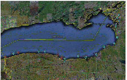
NY Initiative to Keep Lake Ontario Waters Clean State Requests "No-Discharge" Designation from EPA Seeking to safeguard water quality and improve recreational opportunities, state officials announced today that they are calling for New York's portion of Lake Ontario to be designated as a �Vessel Waste No-Discharge Zone� by the U.S. Environmental Protection Agency (EPA).
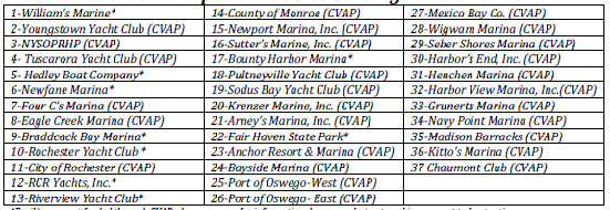
A No-Discharge Zone designation means that boaters are banned from discharging their on-board sewage into the water. Boaters must instead dispose of their sewage at specially designated pump-out stations, which can be found at many marinas (see attached list).
Treated and untreated wastes can deliver pathogens and toxins to local waters and contribute to harmful nutrient loadings. Waste treated by on-board septic systems often contains chemical additives such as formaldehyde, phenyls and chlorine. These pollutants can harm water quality, pose a risk to people�s health, and impair marine life and habitats.
Table 1-Map of Map of Pumpout Locations Serving Lake Ontario |
Table 2- Pumpout Facilities Serving Lake Ontario
The state Department of Environmental Conservation (DEC), in collaboration with the state Environmental Facilities Corporation (EFC) and the Department of State (DOS), has prepared a petition to the EPA requesting the designation to protect the waters of Lake Ontario.
Since 1976, DEC has designated most of the coastal waters and connecting waterways in New York as Vessel Waste No-Discharge Zones. In 2010, DEC announced that it had set a goal of 2012 to establish No-Discharge Zones for all waterbodies and waterways in the state. The Lake Ontario petition is part of DEC�s continuing effort to meet that goal. Approval would extend protection to 326 miles of Great Lakes shoreline from Youngstown in the west, to Cape Vincent in the east.
Upon concurrence by EPA, an opportunity for public comment would be announced later this summer in the Federal Register. When that concludes, EPA will address comments and determination if there are an adequate number of vessel pump-out stations to support the No-Discharge Zone. If EPA concurs, the No-Discharge Zone would be enforced by DEC law enforcement, State Police and local authorities. |
![]()
![]()
Wisconsin
Northern zone musky season opens May 28HAYWARD -- Musky anglers in search of larger fish stand a better chance than their parents did of catching their hearts' desire with the northern musky zone season opening May 28. Preliminary results from fisheries studies are showing that a decade after an overhaul of Wisconsin's musky stocking strategy, the changes are boosting fish size.
"We'll need more surveys and time to fully look at the data but I think it is safe to say that on the subset of lakes where we actually stopped stocking muskies, we have seen a reduction in their abundance but a big improvement in their size," says Steve Avelallemant, the Department of Natural Resources northern fisheries supervisor for the last 25 years. The average proportion of 42" and larger fish in these populations more than doubled, increasing from about 7 percent to about 17 percent five or more years after stocking ended.
Thirty years ago, the rule of thumb was to stock lakes at twice the annual harvest rate. Because there wasn't good information on the harvest, fisheries staff assumed the harvest rate to be one fish per acre, according to Tim Simonson, the DNR's longtime warm-water species specialist, and co-chair with Avelallemant of DNR's musky committee.
So most lakes were getting stocked at two fish per acre, regardless of whether the lake had naturally reproducing muskies. By the late 1990s, the musky world was changing. Higher minimum length limits were in place and catch and release had taken hold, Simonson says. It was clear that the stocking formula overestimated the harvest. In the early 1980s, the projected harvest from 356 Class A, or "trophy waters," was 38,318 fish statewide. By 1990, that total had dropped to an estimated 8,541 fish, and by 2001, only 1,987 muskies were kept by anglers.
So starting in 2001, DNR changed its stocking strategy, a move described in the Natural Resources Magazine article, Long Live the Kings. Each of the 220 stocked musky waters in the state at that time was assigned to a specific stocking practice for 10 years based on its reproductive status. Stocking rates ranged from zero, where stocking was stopped because natural reproduction existed, to a rate of .5, 1 and 2 fish per acre in waters where the fishery depended on stocking.
Since the change, preliminary data on 75 percent of the |
lakes where stocking was stopped shows that 95 percent show some evidence of natural reproduction and that the proportion of larger fish is increasing, Simonson says. In order to confirm these initial results, DNR will be conducting more detailed surveys on several of these populations over the next two to three years, Simonson says.
The better size structure is likely due to several factors including maturation of more abundant year classes of muskies when stocking was greater as well as increased voluntary catch-and-release and the effects of higher minimum length limits where those are in force. The future of our musky fisheries as far as larger fish goes looks pretty good," Avelallemant says. For those anglers who still favor strikes over size, there are plenty of waters to keep them happy as well: 250 of the total 794 lakes or river segments across Wisconsin with musky are so-called "action" waters.Northern zone musky season detailsThe musky season opened May 28 in Wisconsin north of U.S. Highway 10, excluding Wisconsin/Michigan boundary waters, and runs through Nov. 30, 2011. The daily bag limit is one and the minimum length limit is 34" in most cases, but some lakes have special regulations. Please see the �Guide to Wisconsin Hook and Line Fishing Regulations 2011-12."
Wisconsin-Michigan boundary waters opened for musky fishing on May 15. The southern zone musky season opened with the regular game fish opener on May 7 and runs through Dec. 31, 2011.
Lake Michigan waters north of Waldo Boulevard in Manitowoc open for musky fishing May 28. Included in this season are the Bay of Green Bay, the Fox River upstream to the DePere dam, Sturgeon Bay and other bays to Lake Michigan and Green Bay. The daily limit is one, the minimum length limit is 50 inches, and the season closes Nov. 30.
The Lake Michigan season for musky south of Waldo Boulevard in Manitowoc is already open. It runs May 7 through Dec. 31, 2011, and the daily limit is one. There is a minimum length limit of 34".
More information is available on the Wisconsin musky page of the DNR website.
|
![]()
![]()
|
(Click on title or URL to read full article)
EDITORIAL: Block the carp
Researchers look for VHS fish disease in
Winnebago System
Funds to restore Great Lakes available to
farmers in Lake Erie watershed
Invasive species imports flagged
Record 106 lb Missouri Bighead Carp Gene Swope was snagging for paddlefish on Lake of the Ozarks when he hooked and landed an unfortunate Missouri state record. Swope hauled in a 106 lb bighead carp, which easily passed the previous 80 lb state record and outweighs the IGFA all-tackle world record by 16 lbs. However, Swope's catch won't be counted as an IGFA world record because snagging isn't allowed under IGFA rules.
All bait buckets in Minnesota must be emptied The fight to slow the spread of invasives into Minnesota lakes means major changes for the state's 1.5 million anglers following passage of a new law. The biggest change: Anglers will have to drain their minnow and leech buckets when they leave any waters -- not just waters infested with invasive species -- if they want to keep their bait.
Michigan invader stopped at Oregon border: Tenacious zebra mussel hitchhikes cross country A tenacious zebra mussel that hitchhiked across the country, attached to a Michigan boat bought by an Oregon man, was stopped by inspectors there before it could invade the waters of that state.
Group to track walleye in St. Marys A group of several constituents that work with the St. Marys River fishery is conducting a walleye movement study in the river this summer. Walleye from Munuscong Bay have been fitted with internal acoustic transmitters that will allow Lake Superior State University students and fisheries biologists to track their movement |
![]()
![]()
The opinions expressed here are those of the authors and not necessarily those of the GLSFC, its officers or staff.
Reproduction of any material by paid-up members of the GLSFC is encouraged but appropriate credit must be given.
Reproduction by others without written permission is prohibited.
Home | Great Lakes States | Membership | Exotics Update | Great Links
Pending Issues | Regional News | Great Lakes Basin Report | Weekly News / Archives
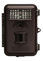 Bushnell
Trophy Cam line to help trail camera users more effectively pattern game and
capture images outside the 45-foot motion activated sensor range. With Field
Scan, users can set the trail camera to capture images at pre-set intervals
of one minute to one hour, while simultaneously capturing live trigger
images, becoming the first in the industry to offer this unique capture
capability.
Bushnell
Trophy Cam line to help trail camera users more effectively pattern game and
capture images outside the 45-foot motion activated sensor range. With Field
Scan, users can set the trail camera to capture images at pre-set intervals
of one minute to one hour, while simultaneously capturing live trigger
images, becoming the first in the industry to offer this unique capture
capability.